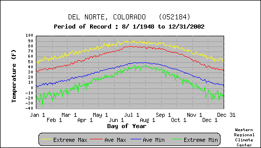
Del Norte Temperature Statistics
Del Norte Precipitation Statistics
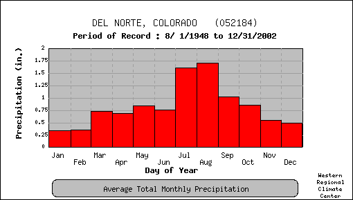
| Jan | Feb | Mar | Apr | May | Jun | Jul | Aug | Sep | Oct | Nov | Dec | Annual | |
| Avg daily max temp (F) | 35.1 | 40.7 | 48.9 | 58.2 | 67.0 | 75.5 | 78.4 | 76.5 | 71.4 | 62.1 | 47.4 | 37.1 | 58.2 |
| Avg daily min temp (F) | 6.8 | 12.3 | 19.9 | 27.0 | 35.1 | 42.5 | 48.2 | 46.7 | 39.6 | 30.3 | 18.7 | 9.1 | 28.1 |
| Num days min temp <=0 F | 8.2 | 3.4 | 0.7 | 0.0 | 0.0 | 0.0 | 0.0 | 0.0 | 0.0 | 0.0 | 0.9 | 5.8 | 16.9 |
| Num days max temp >=90 F | 0.0 | 0.0 | 0.0 | 0.0 | 0.0 | 0.1 | 0.1 | 0.0 | 0.0 | 0.0 | 0.0 | 0.0 | 0.1 |
| Total monthly precip (in) | 0.34 | 0.35 | 0.67 | 0.70 | 0.85 | 0.75 | 1.65 | 1.74 | 1.02 | 0.86 | 0.56 | 0.50 | 10.11 |
| Total monthly snow (in) | 5.4 | 5.7 | 7.5 | 4.7 | 1.3 | 0.0 | 0.0 | 0.1 | 0.1 | 3.7 | 6.2 | 7.5 | 42.1 |
There is a strong diurnal mountain-valley (or drainage) flow in the San Luis Valley. At night cold air sinks from the mountain slopes and pools in the valley basin. As a result Alamosa has considerably colder mornings than Del Norte as shown in the table below. Since Ghost Mine Ranch is at a higher elevation than Del Norte, its diurnal temperature range may be smaller.
| Jan | Feb | Mar | Apr | May | Jun | Jul | Aug | Sep | Oct | Nov | Dec | Annual | |
| Avg daily max temp (F) | 34.2 | 40.6 | 48.8 | 58.2 | 67.9 | 77.9 | 81.8 | 79.3 | 73.3 | 62.6 | 47.0 | 36.1 | 59.1 |
| Avg daily min temp (F) | -2.2 | 5.6 | 15.7 | 23.5 | 33.1 | 41.2 | 47.4 | 45.5 | 36.5 | 24.3 | 11.6 | 0.2 | 23.6 |
| Num days min temp <=0 F | 18.2 | 8.9 | 1.4 | 0.0 | 0.0 | 0.0 | 0.0 | 0.0 | 0.0 | 0.1 | 3.8 | 15.5 | 47.9 |
| Num days max temp >=90 F | 0.0 | 0.0 | 0.0 | 0.0 | 0.0 | 0.4 | 0.8 | 0.0 | 0.0 | 0.0 | 0.0 | 0.0 | 1.4 |